
Elevation Profile
319–370 m
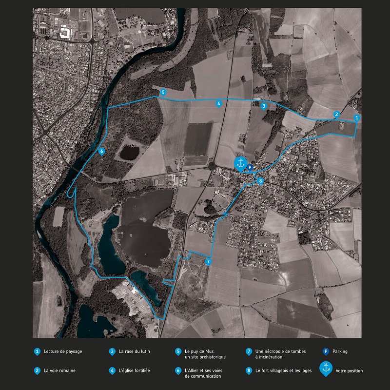
Départ : Du panneau de départ, suivre l’avenue de l’Allier à droite en direction du centre bourg. 100 m plus loin, au carrefour de la mairie, tourner à gauche, puis immédiatement à droite rue St-Laurent. Remonter la ruelle jusqu’à déboucher sur une route. La suivre à gauche sur 250 m jusqu’au rondpoint.
1. Continuer en face, rue du château d'eau, en traversant un lotissement. Quitter alors la route à gauche dans le virage en poursuivant sur un chemin à travers champs. 300 m après, au T partir à gauche. A l’autre intersection, obliquer à gauche en longeant le cimetière des Combes (panneaux Lecture de paysage et La voie romaine).
2. A la D81, traverser et poursuivre sur la Voie Romaine (prudence). Continuer pendant 900 m en ignorant toutes les autres voies (vues sur le Puy-de-Dôme, le Sancy et Cournon-d’Auvergne) (panneau La rase du lutin).
3. A la D1, traverser en face (prudence) et poursuivre jusqu’à l’orée d’un bois (panneaux L'église fortifiée et Le puy de Mur, un site préhistorique). Continuer tout droit en ignorant les deux chemins partant à gauche pour arriver jusqu’à l’Allier. Prendre à gauche sur le sentier et continuer sur 600 m en longeant les berges (panneau L'Allier et ses voies de communication).
4. En vue du pont de Cournon, passer à droite sous le pont et continuer le long des berges pour entrer dans l’Écopôle du val d’Allier.
5. 250 m plus loin virer à gauche en continuant sur un chemin qui marque une boucle avant de rejoindre une ancienne gravière sur la gauche. 400 m plus loin, aux anciennes marches du château disparu de Bellerive, monter à gauche et suivre le sentier en hauteur. Redescendre plus loin sur un chemin qu’il faut suivre à gauche jusqu’au belvédère (à gauche, accès à un observatoire). Continuer à droite jusqu’à l’usine.
6. Quitter alors la route à gauche et descendre en contrebas au bord de l’étang pour en faire le tour au pied d’une haute butte. 250 m plus loin, monter les escaliers à droite jusqu’à un second observatoire. Tourner alors à droite en direction de la route. Peu avant, virer à gauche et la longer sur 250 m.
7. Passer sous la D1 par le passage souterrain, virer à gauche au terrain vague, et emprunter un chemin à travers champs à droite (panneau Une nécropole de tombes à incinération) . Au T, obliquer à gauche sur un chemin qui se transforme en route en traversant un lotissement.
8. 100 m après le virage, descendre à gauche puis immédiatement à droite en passant devant le gymnase et les tennis. Poursuivre jusqu’à déboucher à un carrefour. Monter en face rue des Charmes puis, virer à droite quartier du Torrail.
9. Continuer ensuite à gauche et passer sous la porte de la solidarité pour arriver à l’église. En faire le tour par la droite (panneau Le fort villageois et les loges). Poursuivre alors à droite, passer devant la mairie pour rejoindre l’avenue de l’Allier. Virer à gauche pour retrouver le point de départ.
At a Glance
- Duration
- 2.5hrs
- Distance
- 7.9km
- Elevation +
- +66 m
- Elevation -
- -66 m
At a Glance
Live Weather
Departure / Arrival · Pérignat-ès-Allier
Live conditions
—
Feels like
—
Wind / gusts
—
Visibility
—
Updated: —
Important Advice
Follow the blue signs.
Field notes and images

Étangs de l'Écopôle du Val d'Allier
Captured by David Frobert
Panneau de départ
Captured by CC Billom Communauté
Explore Nearby

From the Allier to Puy de Mur
This 5.7 km loop starts and finishes at Dallet, with 187 m of ascent and an estimated duration of 1 hr 45 min.
Puy de la Poule
Start: From the start information panel in the car park beside the sports ground on Chemin de la Côte, cross the road and take the track straight ahead. Fifty metres after the farm building, branch right and continue on the track (views of Cournon, the Sancy and Puy de Mur). At the fork, descend to the left. At the T-junction, turn left, then after 10m descend to the right. Follow the Allier on the left, then climb to the left to reach the surfaced track. Follow it to the right to a junction beneath the high-voltage line. 1 - Turn left (water catchment area on the right), continue and, on the bend (picnic area), go straight ahead. At the next junction, turn left into the woods, cross a stream and pass beneath two power lines. At the junction facing the village of Mezel, turn right, pass alongside a ruined building and continue to the road. Cross it and head towards Saint-Bonnet. Leave the road and, after the warehouses, descend to the right on a track. Continue to the road (dog training centre). 2 - Follow it to the left for 40 m, then take the track on the right and stay on this main track, keeping left at the next two junctions and heading towards Saint-Bonnet. Reach the road opposite the community hall, turn right, then left onto Rue de la Fontaine Madeleine, then right as far as Rue des Granges. Follow it to the right to the stop sign at the next junction, then take Rue du Château on the left to the church porch. 3 - Take the street that passes around the church to the left and above it. Pass a water tower and climb on a surfaced track to the château entrance. Take the track on the right opposite the entrance. Pass alongside the farm and, at the high point (view of the Chaîne des Dômes), continue to the fork and turn right. At the junction, turn right beneath the power line, then after 80m climb straight ahead to the left (view of the Forez) to a fork. Turn right across the plateau (ignore the descent that leads directly to Mezel) (view of the Livradois-Forez). Pass around a cirque and reach the road. 4 - Turn right, then after 40m climb the leftmost track (another yellow PR route is on the right). Descend to the left on the track, pass above the château and descend into Mezel (dovecote). Continue to Place de la Fontaine, turn right onto Rue de la Font-Grande, left onto Rue Marmondieu, then left before the château. One hundred metres further on, pass beneath the porch on the right, pass the church entrance, take the passage on the right and continue along the left side of the château (12th- and 16th-century château). Descend to the left along Rue Guyot Dessaigne, then left again at Place de l’Église; descend the small staircase just after the market hall, Passage des Buissonnières. Descend Rue de la Balalong to a mission cross (viewpoint). Turn left onto Rue Côte de Peine, then Rue Célestin Tourres. Turn right onto Chemin de la Côte to return to the starting point.

The Puy de Mur tour
Departure: from the departure sign (Fontaine-lavoir), go left towards the village via rue de la Croix de Laire Basse then rue des Noyeraies. Take successively rue de la Paix, rue Marchidial, the stairs and rue de l'Ancienne Église. At the fork, go up to the left to reach the top of the mound (Chapelle) and the orientation table (view of the Chaîne des puys and Limagne). Cross the park, and go down the grassy path. Take rue de la Croix de Laire Haute on the right for 200 meters and turn right onto the first path to join the road (rue Chatel Vieux). 1. Go left for 50 meters then turn right onto the first path. Continue straight on until the road. Cross it, go straight on, then at the crossroads. At the end of the woods, leave the path on the left and continue (view of Limagne and Pont du Château) on this wide path for approximately 2 km until you reach a road. Take it on the left for 100 meters and take the path on the right (view of Sancy and the Chaîne des Puys) up to the first house. 2. Go up left; at the next intersection continue straight ahead. Rejoin the road, take it to the right for 100 meters and turn right onto a path (water reservoir). Follow it along the balcony and go up to the return point at the T-intersection. Turn left and left again into the clearing. Reach the top of Puy de Mur by a path on the left, which continues with stairs then with a second staircase on the right. (360° panoramic view). 3. Go back down 300m by the same path; At the end of the round trip, continue opposite towards Mezel, leaving the path on the right. At the first houses, take Chemin du Trat then opposite Rue du Chemin de Ronde; At its end, turn left onto rue Guyot Dessaigne. At the cross (view of the Val d'Allier, the Sancy and the Chaîne des Puys) go up this street on the left towards the top of the village (on the right, church and castle (12th – 16th century) up to rue Marmondieu. (On the left, at the corner of the car park, Departure from Mezel sign). 4. Follow this street and turn right onto rue de Font-Grande. Just before the roundabout, go left and immediately right. At the dovecote, at the fork, turn right. Continue on this path, go down towards the road and, just before it, turn left. At the intersection go down right. At the road, go right to reach the starting point.