
Elevation Profile
690–1194 m
Départ : Depuis l’esplanade en contrebas du bourg de Viscomtat, emprunter la D42 à droite. Au carrefour de 4 routes, emprunter la D321 en direction de Noirétable. Après 100 m, à la patte-d’oie, emprunter la route montant légèrement à droite. Cette route devient chemin. Continuer sur le chemin principal jusqu’à la D321.
1. La traverser pour emprunter, au bout de 10 m, un petit sentier qui part à droite en longeant la route en contrebas. Retrouver la D321 que vous suivrez à gauche pour emprunter la première route goudronnée en direction de la Fortie. Avant le barrage, suivre la route goudronnée à gauche qui monte au village de la Fortie. Suivre le virage en épingle à droite et au sommet du village, emprunter la route à gauche.
2. À la patte-d’oie, tourner à droite et passer devant la scierie. Continuer sur ce chemin principal. Au carrefour, prendre le chemin en face. À la patte-d’oie suivante, emprunter le chemin de droite jusqu’à la route.
3. La suivre à droite pour passer sur le pont. Suivre ensuite la première route goudronnée montant à gauche jusqu’au village de la Forêt. À la sortie du village, emprunter le chemin à gauche puis, au bout de quelques mètres, tourner sur le sentier montant à droite dans les bois. Garder le sentier principal jusqu’à retrouver une piste forestière.
4. L’emprunter à gauche sur 20 m et au carrefour, prendre le chemin de gauche qui rejoint le magnifique petit village de Seychal. Traverser le village en gardant le chemin à droite (Attention, bien refermer les barrières). Continuer sur ce chemin jusqu’à rejoindre une piste forestière. La traverser pour emprunter le sentier qui monte en face et qui ressort sur la piste forestière.
5. L’emprunter à droite sur 15 m avant de tourner sur le sentier de gauche dans la plantation. Garder ce sentier jusqu’au Cheix Blanc (petit allerretour à gauche jusqu’au pierrier pour le point de vue sur les Bois Noirs, la chaîne des Puys, le Mont- Blanc). Continuer sur le sentier principal qui redescend à travers une plantation jusqu’au deuxième amas rocheux, le Cheix Petit (allerretour à droite jusqu’au pierrier avec une croix pour un point de vue sur les Bois Noirs, Noirétable). Le sentier continue à descendre à gauche jusqu’à retrouver un chemin.
6. Suivre ce chemin à gauche sur 20 m jusqu’à la patted’oie. Continuer tout droit jusqu’à la piste forestière. L’emprunter à droite et garder la piste principale jusqu’au parking de Pierre Pamole. Tourner ensuite sur le chemin de droite qui monte au sommet de Pierre Pamole (tables d’orientation avec vue sur Pierre-sur-Haute, le Massif du Sancy, la chaîne des Puys, les Bois Noirs, les Monts du Livradois, le lac d’Aubusson d’Auvergne et le Mont-Blanc).
7. Au sommet, emprunter le sentier qui descend après la deuxième table de lecture et retrouve un chemin plus en contrebas. Emprunter le chemin à droite et garder le chemin principal jusqu’à retrouver le Col du Pertuis. (Possibilité de suivre le balisage «Virée des Rocs 4» pour le tour complet).
8. Au Col, prendre la piste à droite, puis tout de suite le chemin descendant à gauche. Au bout de 10 m à la patte-d’oie, garder le chemin principal qui part à droite. Au carrefour de 4 chemins, continuer en face jusqu’à un chemin plus large que l’on emprunte à gauche. Dans le hameau de l’Ojardie, descendre légèrement à gauche et emprunter la première route à droite. Au carrefour au centre du village, bifurquer à gauche pour retrouver la D42 à droite.
9. À la sortie du village, prendre un chemin à gauche. À la patte-d’oie, continuer sur le chemin de droite jusqu’à la D42. Juste avant de rejoindre la D42, emprunter la petite route goudronnée qui descend légèrement à gauche pour traverser le village du Rabéré et remonter à la D42. L’emprunter à gauche. Dans le village de Mondière, prendre la deuxième route à gauche juste après le lavoir (panneau de sens interdit). Dans le bourg de Viscomtat, retrouver la D42 que vous empruntez à gauche pour retrouver le parking.
At a Glance
- Duration
- 5.0hrs
- Distance
- 15.9km
- Elevation +
- +668 m
- Elevation -
- -667 m
At a Glance
Live Weather
Departure / Arrival · Viscomtat
Live conditions
—
Feels like
—
Wind / gusts
—
Visibility
—
Updated: —
Field notes and images
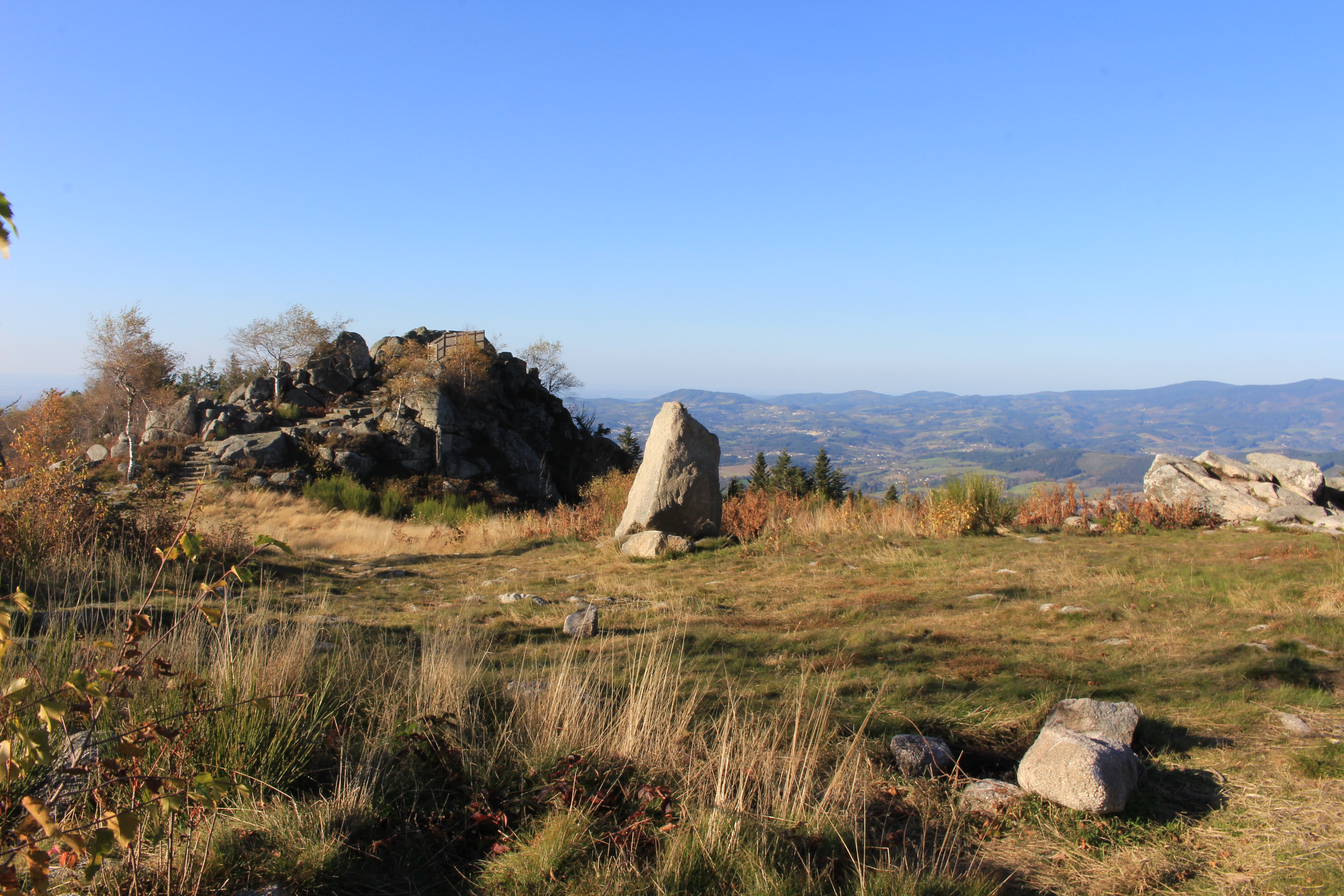
Point de vue depuis Pierre Pamole
Captured by Maison du Tourisme Sébastien Giraud
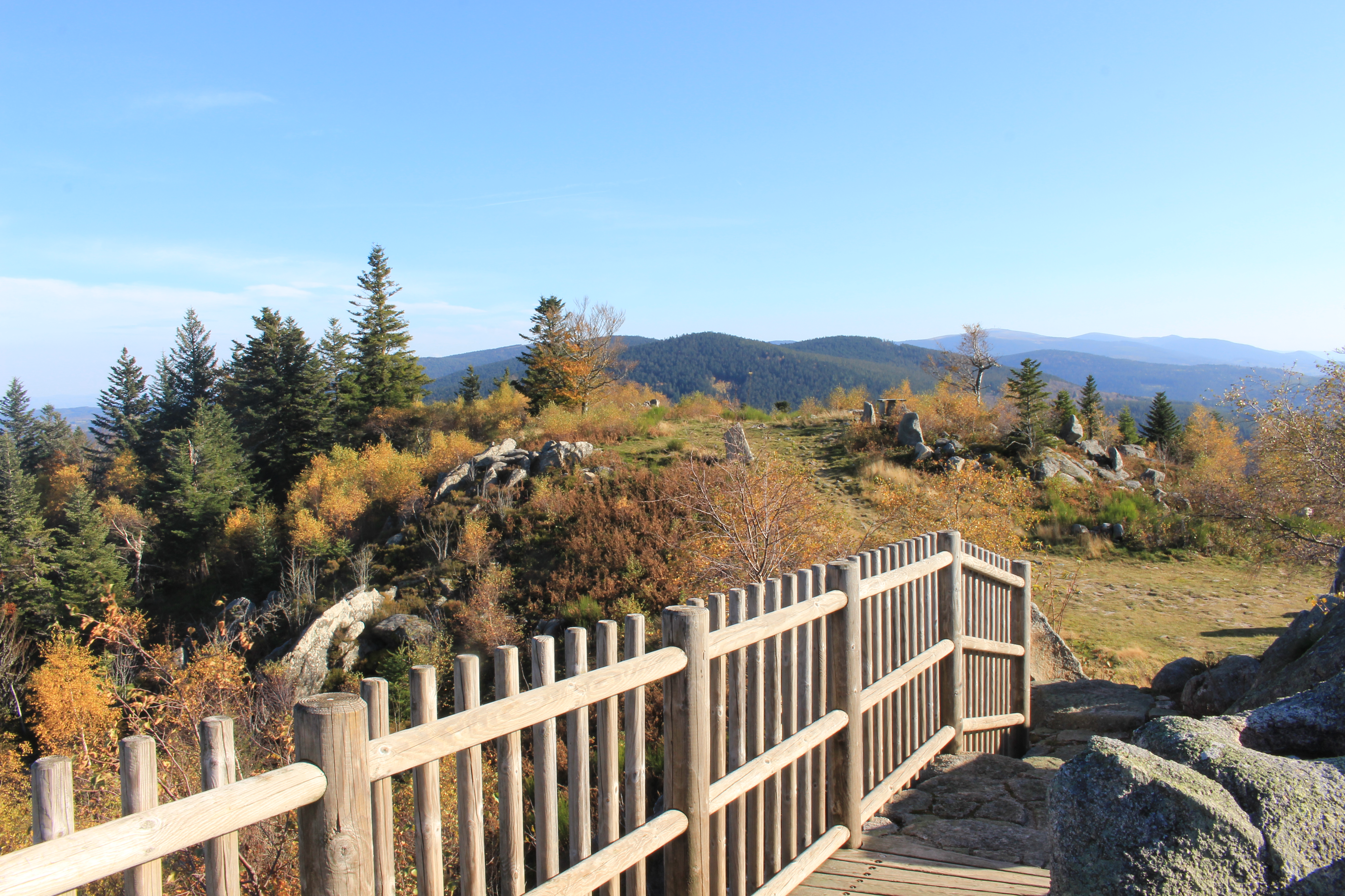
Point de vue depuis Pierre Pamole
Captured by Maison du Tourisme Sébastien Giraud
Explore Nearby
The Bridges Circuit
Start: From the church in La Renaudie. Descend the main road (D102), then continue straight ahead at the junction onto the D41 (towards Le Brugeron). Follow the D41 to the Croix de Ste Agathe. Take the road on the right towards Le Clef (view of the village of La Renaudie). At the entrance to the hamlet, just after a barn, take the stony track on the right; pass the renovated house and continue along the grassy track. Continue for approximately 800 m from Le Clef, then turn sharply right to cross the Rioubet stream. Climb the same track to La Chossonie. 1. Just after the first house, leave the road for the track descending slightly to the left. At the fork, continue right (view of the Chaîne des Puys). At the entrance to La Vialle, immediately climb to the right. At the top of the village, cross the D41 and take the track opposite between 2 low walls. On the climb, leave the track and turn left (view of the Sancy massif and the Chaîne des Puys). Continue straight ahead, then turn left near the cross. 2. On reaching the hamlet of Thérias (on a bend), follow the road to the left for 50 m, then turn right towards Les Gouttes at the junction. 20 m farther on, at the cross, leave the road and take the track on the left. At the junction, take the small road opposite (towards La Chaugne). 15 m farther on, leave this road for the track on the right. Cross the stream and continue straight ahead. Pass alongside a hamlet (Les Champs-Elysées) and, at the junction, continue on the same track opposite to Le Garret. 3. In the village, climb the small road opposite to reach the D41. Cross it and take the track opposite. At the fork, continue straight ahead. In the hamlet of Le Cheix, go around the house and continue through the forest to the ruins of the village of Vironesse. 4. At the ruins, continue along the main track for approximately 250 m, then turn onto the first track on the right. Remain on the same track to the Pale stream. Follow the stream on its left-hand side (the track is very wet in places) to reach the D 317. 5. Follow it to the right for 500 m. On reaching the hamlet of La Goutte, take the D 102 to the right (towards La Renaudie). 150 m farther on, on the bend, turn left and follow the right-hand edge of the field. At the junction, take the track on the right. Follow this climbing track for 1.5 km, then turn left at a crossroads of 4 tracks. Remain on the main track until you reach a road. 6. Follow the road to the right for 200 m, then turn right. Beside a ruin, continue straight ahead; follow the Couzon stream. Ignore the forest track branching right and remain on the same track to a ford. 7. Just before the ford, take the track bearing right. Follow the road to the left, then take the first track on the left. At the fork, continue straight ahead. At the junction of several tracks, turn left and then immediately right. Follow the same track to a road. 8. Follow it to the left, then turn left at the next junction. 150 m farther on, turn left again and cross the fields. On reaching the D 101 at the entrance to the village of La Chambonie, beside the cemetery, turn right for 5 m and then immediately take the road on the right. Follow it for 500 m. 9. Beside a small wrought-iron cross, just before an isolated house, turn right and climb through the woods. At the top of the hill, take the clearest track on the right. On leaving the woods, turn sharply left. 10. Follow the road to the right. Cross the hamlet of Le Verdier and remain on the same road. Follow the D 41 to the right. At the large junction, leave the D 41 and take the D102 to the right (towards La Renaudie). Enter the village and return to the church.
Des Margerides au Grun de Chignore (circuit route n°7)
Discover this trail through the heart of Livradois-Forez.
Du col de la Loge au col du Béal (circuit route n°6)
Discover this trail through the heart of Livradois-Forez.