
Elevation Profile
937–1259 m
Départ : Depuis l’office de tourisme, place de l’Aubépin, suivre la
D996 en direction de Montbrison, jusqu’à la sortie du bourg.
1. Passé le lieu-dit le Chalard, quitter la route par le chemin à gauche bordé d’arbres. Traverser le hameau de La Grange Neuve et continuer à monter tout droit.
2. Au hameau de Chabrioux, suivre la route jusqu’à l’intersection
suivante.
3. Quitter la route à droite par le chemin puis tourner à gauche
vers le transformateur. Passer le ruisseau de la Chantosselle avant de prendre à gauche à la fourche.
4. Traverser la route pour éviter le hameau de Saint-Yvoye et rejoindre la route plus loin.
5. Virer à gauche en direction des Chorons. Délaisser ensuite la
route à gauche pour monter par le chemin à droite.
6. Au carrefour, bifurquer à droite pour venir traverser la piste forestière à l’intersection et prendre le chemin en face.
7. Laisser la piste à droite pour emprunter le sentier à gauche qui débouche sur une autre piste menant aux Prats-de-la-Chaux.
8. Aux dernières maisons, franchir un ru et remonter sur la
gauche. Poursuivre à gauche à la fourche.
9. Emprunter la piste à gauchesur 350 m, puis virer à droite. Après 450 m de chemin, prendre à gauche le chemin en sous-bois.
10. À l’intersection, tourner à droite. 200 m après la maison de la
Reculas, descendre à gauche pour rejoindre la Faye Marchand.
11. À la route, virer à gauche.
12. Entrer dans le hameau de Bergougnoux et bifurquer
sur le premier chemin à droite. Il longe en hauteur le ruisseau de la Vaissière sur 1,7 km.
13. Franchir le pont sur la Vaissière puis à la fourche,
tourner à gauche et longer le ruisseau sur l’autre rive sur 800 m.
14. Prendre la route à gauche pour rejoindre Saint-Anthème et l’office de tourisme par la D996.
At a Glance
- Duration
- 4.0hrs
- Distance
- 13.9km
- Elevation +
- +433 m
- Elevation -
- -432 m
At a Glance
Live Weather
Departure / Arrival · Place de l'Aubépin, Saint-Anthème
Live conditions
—
Feels like
—
Wind / gusts
—
Visibility
—
Updated: —
Field notes and images
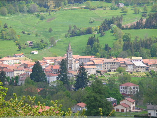
Saint-Antheme
Captured by mairie de Saint-Anthème
Explore Nearby
Around the Pradeaux dam
Departure: From the Col des Pradeaux, take the path up to the dam. At the next crossroads, take the path uphill on the right. Before the reservoir, take the path on the right and keep the main path until you reach the woods. Cross the woods opposite and continue opposite until the crossroads of 4 paths. 1. Take the path opposite and continue to the dam. Follow the dam on the right. Towards the “tail” of the dam, take a path going down to the left. Continue to follow the dam on the right and cross the 2 wooden footbridges. 2. At the exit of the second footbridge, turn left on the path and continue to follow the dam for 600m. Cross a small stream on the 3rd footbridge, continue opposite for 300m before going up a path on the right to find the path. 3.Take it on the left and continue to pass next to the dam. At the next crossroads, turn left and keep the main path going down to the Col des Pradeaux.
Beauvoir
Château de La Roue All that remains of this château is part of the enclosure wall and the square tower visible from the village. This keep, known as the “Tour de Pierrefort” in tribute to the last lord of the estate, “Hérail de Pierrefort La Roue”, dates from the 14th century and was restored in the 19th century. The original building probably dates back to the 13th century. It was then a powerful feudal château, forming part of the ring of fortifications around the county of Forez. From an early date it belonged to the La Roue family, known since the 12th century, who dominated the Ance valley from their three châteaux: La Roue, Montpeloux and La Chaulme.

Dore Loop
The Livradois-Forez Regional Natural Park, a land of grassland and woodland, promises a memorable journey between valleys and ridges.